
Starlink Satellites and the Night Sky - Simulation
For those unaware of it - "Starlink" is a constellation of 12000 satellites planned by SpaceX company, aimed to provide global internet coverage. The company had already obtained permission from International Telecommunication Union for 12K satellites in 3 shells (at altitudes of 340, 550 and 1150 km), and filled a request for 30000 more satellites (at altitudes of 328 and 580 km). Several hundreds of satellites had already been launched (in lots of 60).
There are other similar projects: "OneWeb" company plans to put ~650 satellites at 1200km altitude (a few dozens had already been launched). Amazon's "Kuiper" projects involves launching ~3200 satellites at ~600km altitude. "Telesat" company aims to launch 100 to 500 satellites at 1000 km altitude. For reference - there are currently about 5000 satellites in earth's orbit.
One of the aspectes which worry both professional and amateur astronomers (as well as nature enthusiats and photographers) is the effect these satellites create in our already crowded night sky, since many of them will be illuminated by sun and visible during the night (during the entire night in some cases).
I used a simulated TLE orbital elements file provided by "howmanystarlinkswillfillyoursky.com" website and Stellarium planetarium software in order to visualize the number of visible satellites during a typical summer night (June) from +32 degrees latitude. The "Standard magnitude" was set to 6.0m (magnitude when a satellite is 50% illuminated at 1000km altitude). The orbital data for the future 340km and 1150km shells is a speculation.
A fast forward video of the whole sky, while all visible and illuminated satellites are shown as a symbol (regardless of their brightness). North is up:
A fast forward video of the eastern horizon, with "realistic" representation of stars and the satellites visible with a naked eye from a dark location through the night:
A real time video of the big dipper region, with "realistic" representation of stars and the satellites visible with a naked eye from a dark location 1.5 hours after sunset:
A fast forward video of North America nebula (NGC7000), to demnostrate the effect on astrophotography. All visible and illuminated satellites and shown.
The following diagram (to scale) illustrates how starlink orbital shells (shown in red) are illuminated by the Sun when it is at different altitudes below the horizon.
We can see that the lower the sun is - the fewer satellites are illuminated (and they are more distant). At certain stages the lowest shells won't be visible at all, and the higher shells will be only visible in the northern part of the sky. Also the "swarm" of the satellites near the horizon will be mostly invisible due to their distance and atmospheric effects.
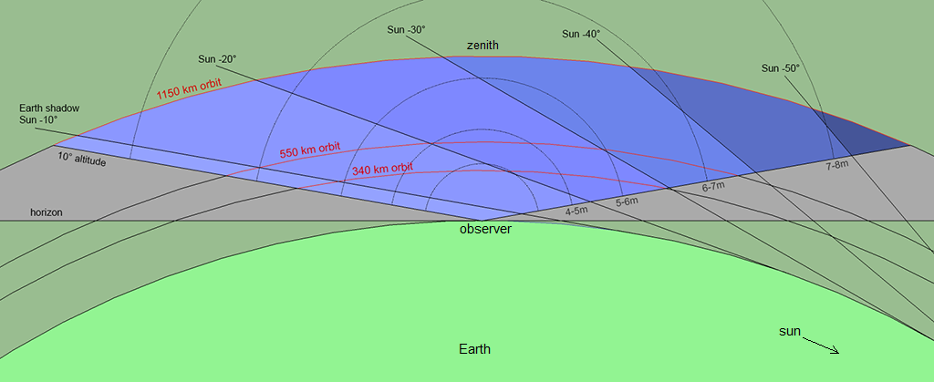
Diagram of Starlink satellites orbital shells, and illumination by Sun at different altitudes
The "worst case" will be experienced during the summer, in northern half of the sky (for northern hemisphere), where the satellites will be visible through the entire night. The "best case" will be during the winter, at midnight, when the sky will be virtually free of any satellites, except for the horizon.